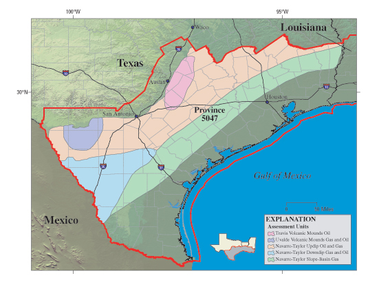
The pink area in the map above shows Travis Volcanic Mounds aka "Serpentine Plugs": GCAGS Transactions Volume 32 (1982)
Since their discovery in 1915, hydrocarbon traps in and around "serpentine plugs" have produced about 47 million barrels of oil, and have significant potential for additional small discoveries. Production is from isolated reservoirs within mounds of altered volcanic tuff and associated shoal-water carbonates. A review of the more than 200 volcanic centers and intrusive bodies of South and Central Texas has led to development of stratigraphic and seismic models useful in exploration and production.CENTRAL TEXAS TRAVIS VOLCANIC MOUND PROSPECTS
The so-called serpentine plugs are largely tuff mounds formed by accumulation of volcanic ash (altered to palagonite) on the seafloor around a submarine volcanic vent. Volcanic activity peaked during deposition of the chalk and marl of the upper Austin and lower Taylor Groups (about 80 million years ago). After their eruption, the tuff mounds localized the deposition of shoal-water carbonates with good porosity and permeability. Low-permeability, organic-rich marine shale and marl of the Taylor Group capped the carbonates, serving as both a hydrocarbon source and a stratigraphic seal. Compactional draping of overlying San Miguel and Olmos sands, with minor offset faulting, created important additional traps in South Texas.
Central Texas volcanic centers are highly aligned along strike-oriented regional faults and fractures of the Balcones and Luling systems. The magmas in both Central and South Texas were ultramafic and alkaline, suggesting that partial melting occurred at depths of about 40 miles (60 kilometers). The magma rose rapidly to the surface, probably in an extensional stress regime controlled by pre-Tertiary Balcones-Luling faults.
The palagonite tuff of a typical productive volcanic center has low seismic velocity and is encased in high-velocity carbonates. The strong velocity contrast, coupled with the distinctive shape of the tuff mass, yields a characteristic seismic pattern. Modern seismic techniques, together with stratigraphic data, allow accurate delineation of buried tuff mounds and prediction of productive carbonate facies.
A Texas based company has leases on a magnetic anomaly in central Texas that appears to be a Travis volcanic mound, and thus a potential undiscovered oil field. Travis mounds are ancient volcanoes that erupted during the Late Cretaceous (70 to 80 million years ago) and formed mounds on the shallow sea floor. The mounds were partially eroded and then covered with younger sediments. The mounds in central Texas are generally referred to as “Travis volcanic mounds” for the surface exposure of one of these mounds in Travis County. The mounds are commonly called “serpentine plugs” because the mineral serpentine commonly occurs in the mounds. Some of the minerals that occur in these mounds are magnetic, hence the magnetic anomalies over these mounds. The mounds have formed structurally high areas in the subsurface that provide traps for oil and gas.
Thirty-eight oil fields in central Texas are associated with Travis volcanic mounds. These fields range in size from 3000 barrels to 11,500,000 barrels of oil recovered, and occur at depths between 900 feet and 1800 feet. Some wells in the mound fields have produced as much as 5000 BOPD (barrels of oil per day) initially, but the initial production of most wells was between 25 BOPD and 100 BOPD. Most of the better wells were located near fractures that are prevalent in the mounds. Most of the oil fields that are associated with Travis volcanic mounds were discovered in the 1930’s, 1940’s, and 1950’s, although six fields were discovered between 1913 and 1929 and three fields were discovered between 1964 and 1977. Over half of the fields are still active including some of the early discoveries. Some of the first oil fields found on the Travis volcanic mounds were discovered by farmers drilling water wells.
Oil is found in at least four different geologic settings in the mounds. Much of the oil occurs in porous areas within the generally altered volcanic igneous rocks that form the mounds. Some oil is found in sedimentary rocks (sandstones and limestones) within the mounds, some oil occurs in sedimentary rocks that overlie the mounds, and some oil is trapped in sedimentary rocks that pinch out on the flanks of the mounds. Thus there are non-productive areas within the confines of the fields associated with the mounds. This prospect appears to cover about 300 acres.
The magnetic anomaly associated with this prospect is comparable to the anomalies associated with one million to three million barrel fields, although the size and intensity of magnetic anomalies is sometimes misleading. Most of the magnetic anomalies that occur in the area are associated with Travis volcanic mounds. The other magnetic anomalies have not been drilled but are believed to be Travis volcanic mounds. A geochemical survey acquired recently found significant (anomalous) concentrations of petroleum hydrocarbons in the soil over the prospect. This suggests minute leakage from an accumulation of hydrocarbons at depth. Additionally, the operator has acquired satellite data that suggest the presence of soil within the prospect that has been altered mineralogically. This condition has been observed in soils over known oil and gas fields. All of these data together suggest a fairly high probability that a commercial accumulation of hydrocarbons (likely oil) exists under the prospect.










-759725.jpg)