
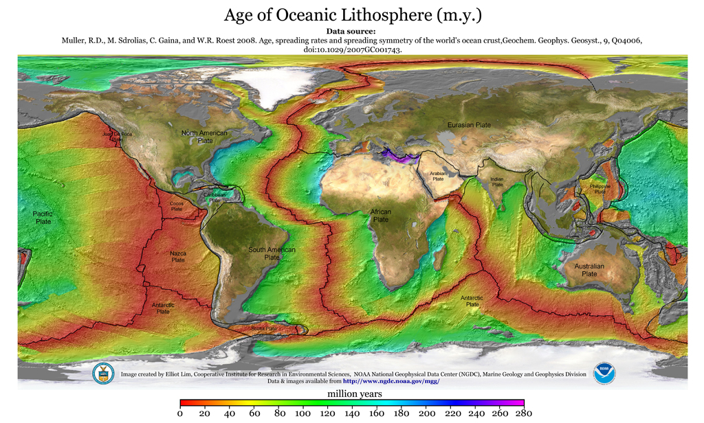
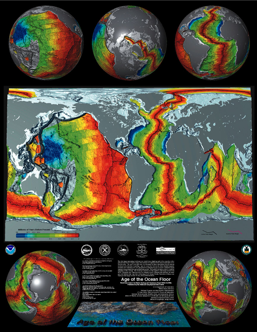
"It is established fact, however, that there is not any physically observed discontinuity between deep crust and upper mantle at around 100 km depth, and the continents are observed to have continuous mantle rock roots extending as deep as 600 km (Grand, 1987; Grand et al., 1997). So the question is naturally raised: How is it possible for the upper 100 km of a continent, e.g., North America, to move horizontally by several thousand kilometers at all, under any circumstances, when global seismic tomography data indicate deep continuous roots from the surface down to 600 km depth?" -- Stavros T. Tassos (seismologist) and David J. Ford (geologist), 2005
"Subduction leads to mythology." -- Me, noob, March 2009
Via Louis Hissink's Crazy World: Plate tectonics subducted. (Hat tip: Anaconda)
“This tomographic image alone,” says Choi, “is enough to bury the subduction models.”


-759725.jpg)
9 comments:
What are the little black dots in the illustration?
They look suspiciously like earthquake hypocenters.
Every time there is an earthquake the radius of the Earth increases.
Every time there is an earthquake the radius of the Earth increases.
That's a pretty bold statement. I take it that you agree that the little black dots are hypocenters.
Hypocenters that descend (trend-wise) in the direction of the Australian plate in accordance with GPS data... Fascinating.
Earthquakes happen at fault zones where tectonic plates come together and move against each other in violent spasms when tension builds up.
That's the common perception and it often happens that way, but not always:
The New Madrid earthquakes of 1811 and 1812 are examples of earthquakes that happen within tectonic plates.
Now, supposedly there is a failed rift (the Earth pulling apart?) that somehow caused the quake, but there is a better explanation:
The crust thusted upward as pressure from an expanding Earth buckled the tectonic plate in that area.
The evidence?
The Mississippi river ran backwards.
No, I kid you not, the mighty Mississippi with all that force of water running down stream was reported to flow back UPSTREAM.
Some reports claim the river flowed backwards for as long as 24 hours. Still any backward flowing is extraordinary.
What would cause this?
Not just shaking from side to side as is normally the case, but a great uplifting of the crust.
Think about that, to make a river of such great force and power run backwards in its channel would require a substantial increase in elevation in the channel bottom in the river.
Vast fissures were reported to have opened up.
Various explanations have been given, but little conventional consideration has been given to an expanding Earth hypothesis.
The 2004 Indian Ocean Boxer day earthquake and tidal wave also is a candidate for a lurch upward in the crust as the Earth expanded.
So-called "subduction" was not the cause as has been commonly assumed.
See the Doug Choi article on this issue: Plate tectonics subducted.
Within the article is this telling statement (remember, they are not arguing for an expanded Earth):
"The unusual level of stress accumulation in the Indonesian arc may be due to the very active vertical movement in this region in recent times, as indicated by raised or buried modern coral reefs."
Oh my goodness.
It [seismic-energy transmigration concept] fits in with the proposal that the upduction of mantle material is responsible for tectonic phenomena in trenches, arcs and backarc zones – a view confirmed by the direction of displacement of the earth’s rotation axis following the Boxing Day quake and other major earthquakes (Scalera, 2005)."
Upduction!
In other words, upward and outward movement by the Earth's crust (expanding Earth).
Jeffery,
You should read the article and then you will know what the imaginary mathematical dots represent.
"Seismotomographic images of other Wadati-Benioff zones show blobby, bent, or wavy high-velocity zones, often discontinuous, with vertical zones aligned with deep fractures, and horizontal zones below about 500 km (Choi, 2004). A great deal of special pleading is required to reconcile these images with the subduction model. The connection between faster mantle zones and deep fractures (which plate tectonicists have consistently overlooked) suggests that the faster zones have lost volatiles and liquids through the fractures, and that the higher velocities reflect the degree of chemical depletion rather than thermal variations."
You should read the article and then you will know what the imaginary mathematical dots represent.
They appear to be hypocenters, and the article does not directly address the dots. What do you suppose they are, if not hypocenters? Elsewhere on that site, similar dots are hypocenters.
@anaconda;
remember, they are not arguing for an expanded Earth
That is correct... they seem to hold both theories in contempt.
Kinda sad while we were here arguing about this, the two plates were building up pressure and people died. A proper theory of plate tectonics might (one day?) enable us to predict earthquakes, saving lives around the world.
The Amazon once flowed into the Pacific as some of you will know.
Underwater detonation of fusion devices can set off clathrates to produce unanticipated additional force.
Anyone know of such tests?
Aceh was supposedly a 9.3 yet it had far less disturbance than the latest Javan quakes. Each one on the scale is a ten times higher force, therefore Aceh was 100 times greater despite being reported as only a 6.3 initially.
The Amazon once flowed into the Pacific as some of you will know.
That fact is based pretty strongly on Plate Tectonics.
How odd that you'd agree with it.
Post a Comment