

Allegedly these are useful in the search for oil and gas. Don't ask me how.
Technical University of Denmark: Global Gravity Field Model.
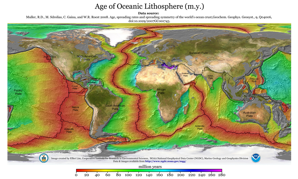
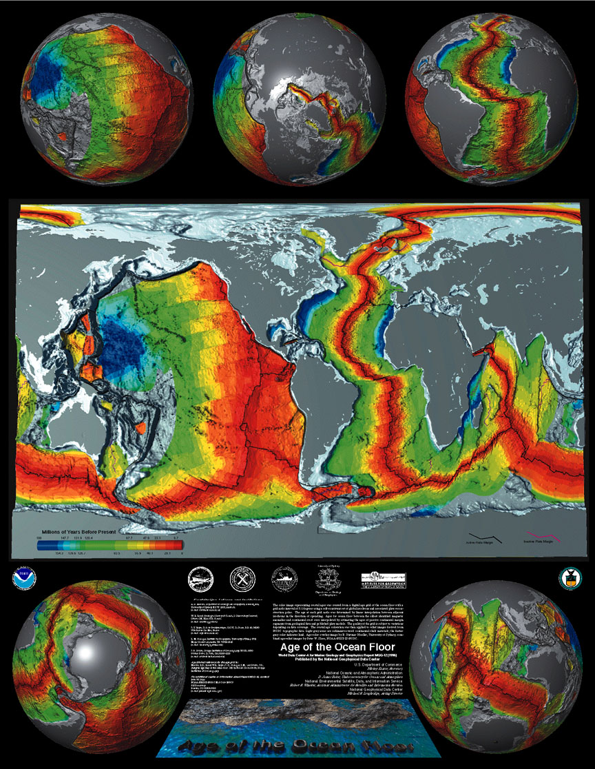
The global gravity field model shows the gravity variations over the global ocean as mapped by satellite. On land the field have been augmented with the best available terrestial gravity field com complete global coverage. Gravity changes are mainly caused by the changes in the attraction of mass under the surface.What changes in the attraction of mass are occuring under the surface?


-759725.jpg)
7 comments:
From Science Daily:
A new map of the Earth’s gravitational force based on satellite measurements makes it much less resource intensive to find new oil deposits. The map will be particularly useful as the ice melts in the oil-rich Arctic regions. Ole Baltazar, senior scientist at the National Space Institute, Technical University of Denmark (DTU Space), headed the development of the map.
The US company Fugro, one of the world’s leading oil exploration companies, is one of the companies that have already made use of the gravitational map. The company has now initiated a research partnership with DTU Space.
“Ole Baltazar’s gravitational map is the most precise and has the widest coverage to date,” says Li Xiong, Vice President and Head Geophysicist with Fugro. “On account of its high resolution and accuracy, the map is particularly useful in coastal areas, where the majority of the oil is located.”
Ole Baltazar’s map shows variations in gravitational force across the surface of the Earth and knowledge about these small variations is a valuable tool in oil exploration. Subterranean oil deposits are encapsulated in relatively light materials such as limestone and clay and because these materials are light, they have less gravitational force than the surrounding materials.
H/T Bloggin' Brewskie
http://www.sciencedaily.com/releases/2009/02/090226110812.htm
ABIOTIC OIL EASIER TO FIND
(hat tip Bloggin Brewskie & BF)
New Oil Deposits Can Be Identified Through Satellite Images
ScienceDaily (Feb. 27, 2009)
Man isn't running out of oil, Man is running into oil.
Thank you for the maps, those are beautiful. Anyhow, I think that the volumetric mass density of the Earth is non-uniform and thereby creates a non-uniform gravitational field (variations measured as mGal=10^-5 m/sec^2 ranging at +/-60 mGal) that is more defined at close proximities than further away. Actually, at a far enough distance all planets look to be or can be more appropriately approximated as point masses at the center of center of mass (the point about which a mass will rotate).
Anaconda, that is a cool slogan.
OIL, OIL, OIL OLIVE OIL, YOUR QUITE THE GIRL
Proposed Extraction Process May Have Economic, Environmental Benefits
ScienceDaily (Sep. 24, 2008) — "A researcher from the University of Alberta has proposed an experimental electrical heating process to draw oil from largely untapped deposits, which could yield major rewards for oil production and be more environmentally sound than current extractions processes."
Think electromagnetism and oil. Future scientists may conclude that ages with high abiotic oil formation in the Earth's crust were due to sharp increases in the electromagnetic intensity of the Birkeland currents between the Sun and the Earth, which in turn increased the electromagnetic level of activity in the Earth's crust.
This would be manifested by increased earthquake activity, volcanic activity, and mid-ocean ridge activity.
During times of increased Birkeland current acitivity between the Sun and Earth of several magnitudes the Earth comes electromagnetically alive!
Scientists Develop Model To Map Continental Margins
ScienceDaily (Sep. 9, 2008) — "Scientists at the University of Liverpool have developed a new exploration method to assist the oil and gas industry in identifying more precisely where the oceans and continents meet."
And:
"Geophysicists at Liverpool have produced a mathematical technique to process satellite data that can map the thickness of the Earth's crust under the oceans in order to locate where the continents meet oceanic crust. The technique has been used to measure the crustal thickness of areas such as the South Atlantic, the Gulf of Mexico and the Arctic to identify new areas for oil and gas reserves."
Man isn't running out of oil, Man is running into oil.
Even more good stuff you have got there Anaconda.
Post a Comment